 North Carolina
Annual Rainfall and Climate Data, see below for individual
cities
North Carolina
Annual Rainfall and Climate Data, see below for individual
cities
North Carolina
Annual Rainfall and Climate Data, see below for individual
cities
North Carolina city precipitation totals
| City | Avg Annual Precip | Avg Annual Snow | Avg. # days of Precip | Avg # thunderstorm days | Avg # hail days | Avg # severe thunderstorm watches per year | Avg # tornado watches per year | # of tornadoes reported in county, 1960-2010 |
| Asheville | 47.07 | 15.1 | 125 | 45 | 1 | 2 | 6 | 6 |
| Cape Hatteras | 57.75 | 1.9 | 120 | 42 | 0 | 7 | 6 | 28 |
| Charlotte | 43.51 | 5.8 | 111 | 41 | 1 | 4 | 8 | 20 |
| Greensboro | 43.14 | 9.2 | 116 | 43 | 1 | 3 | 8 | 10 |
| Raleigh | 43.05 | 7.6 | 112 | 42 | 1 | 6 | 10 | 25 |
| Wilmington | 57.07 | 2.0 | 117 | 47 | 1 | 6 | 6 | 12 |
|
||||||||
North Carolina Precipitation Records
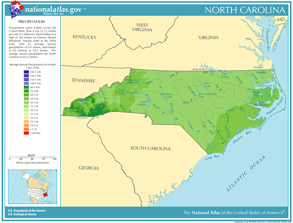
- Driest location ranked by lowest annual average precipitation: Asheville, western North Carolina, 37.32"
- Wettest location ranked by highest annual average precipitation: Lake Toxaway, western North Carolina, 91.72"
- Snowiest location ranked by highest annual average snowfall: Grandfather Mountain, western North Carolina, 57.8"
- State precipitation record for 24 hours - Altapass, western North Carolina, 7/15-16/1916, 22.22"
- State precipitation record for 1 year - Rosman, western North Carolina, 1996, 129.60"
- State snowfall record for 24 hours - Mount Mitchell, western North Carolina, 3/13/1993, 36.0"
- State snow record for 1 season - Mount Mitchell, western North Carolina, 1997-1998, 176.0"
- Cape Hatteras, North Carolina is considered the most hurricane-prone city in the United States, with an average of a hurricane hitting within 60 miles of the city every 2.5 years
- A major severe weather outbreak affected North Carolina on April 16th, 2011. The 30 confirmed tornadoes across the state broke the single-storm and single-day outbreak records for the state. The previous record was from March 1984 with 22 confirmed tornadoes.
- Average winter snowfall over North Carolina ranges from about inch per year on the Outer Banks and along the lower coast to about 10 inches in the northern Piedmont and 16 inches in the southern Mountains. Some of the higher mountain peaks and upper slopes receive an average of nearly 50 inches a year
- On April 15, 1987 severe thunderstorms developing along a cold front produced severe weather in North Carolina.
Drifts of hail up to two feet deep were reported in central part of the state
- North Carolina temperature averages and extremes, Charlotte climate extremes/averages, precipitation and temperature data for all U.S. states and interesting Top 10 U.S. climate extremes
Data sources: National Climatic Data Center, Severe thunderstorm / tornado watch data period is 1999 - 2008, NOAA Storm Prediction Center, Tornado climate data - NOAA Storm Prediction Center, State lightning flash density average - 1997-2011, Vaisala