Alabama Annual Rainfall and Climate Data - see below for individual
cities

| City | Avg Annual Precip |
Avg Annual Snow |
Avg. # days of Precip | Avg # thunderstorm days | Avg # hail days |
Avg # severe thunderstorm watches per year |
Avg # tornado watches per year |
# of reported tornadoes in county - 1960-2010 |
| Birmingham | 53.99 | 1.9 | 117 | 57 | 2 |
12 |
10 | 69 |
| Huntsville | 57.51 | 1.5 | 117 | 54 | 2 | 17 | 8 | 54 |
| Mobile | 66.29 | 2.7 | 117 | 79 | 1 | 21 | 16 | 71 |
| Montgomery | 54.77 | 0.4 | 122 | 59 | 1 | 20 | 14 | 33 |
| Alabama
Precipitation Average - 58.28 inches - 4th wettest in U.S. Alabama Tornado Average - 20.1 per year - 14th highest in U.S. |
||||||||
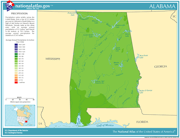
Alabama Precipitation Data
Driest location ranked by lowest annual average precipitation: Montgomery, central Alabama, 48.36"
Wettest location ranked by highest annual average precipitation: Robertsdale, southern Alabama, 67.31" Snowiest location ranked by highest annual average snowfall: Valley Head, northeastern Alabama, 5.3" State precipitation record for 24 hours - Dauphin Island, southwestern Alabama, 7/19-20/1997, 32.52" State precipitation record for 1 year - Evergreen, southern Alabama, 1975, 114.01" State snowfall record for 24 hours - Florence, northwestern Alabama, 12/31-1/1/1964, 19.2" State snow record for 1 season - Florence, northwestern Alabama, 163-1964, 27.9" 'Storm of the Century" - On the evening of March 12, 1993, a low pressure system began to strengthen in
the Gulf of Mexico and move northeast towards Alabama. By the next morning, a snow storm of record proportions had
blasted Alabama with more than a foot of snow in a band from Birmingham northeast to DeKalb and Cherokee Counties.
Every square inch of the state received some measurable snowfall. The heavy snow along with 40 to 55 mph wind caused
widespread power outages and brought most travel to a standstill. Damages exceeded 50 million dollars. During the late afternoon and evening hours on April 3rd, 1974 at least 8 tornadoes, including 4 violent, long-lived storms,
brought widespread destruction to northern Alabama. This tornado "Super Outbreak" that also affected 12 other
eastern states caused over $50 million damage in Alabama. The F5 tornado, that nearly wiped the town of Guin off
the map, was one of the most powerful twisters ever to strike the United States, and its path through the Bankhead
National Forest could be seen on satellite pictures months afterwards On the night of September 12th, 1979, the eye of Hurricane Frederic passed over Dauphin Island and then made landfall
on the Alabama coast near Bayou La Batre. Peak wind gusts over 135 mph were felt along the Alabama coastline, and
hurricane force gusts were felt as far inland as Choctaw County. Massive damage, totaling over $1 billion, was felt along
the coast, and nearly 90 percent of the Mobile area lost electrical power due to the storm. After it made landfall, Frederic
moved north along the Alabama/Mississippi border dropping from 3 to as much as 10 inches of rain along its path.Alabama temperature records and averages
Precipitation data for other U.S. states
Data sources: National Climatic Data Center, severe thunderstorm / tornado watch data - Data period is 1999 - 2008, NOAA Storm Prediction Center